
Grand Challenges Team Engages Students and Statewide Partners in Methane and Waste Heat and Water Remediation Project
September 30, 2024
A cross-disciplinary team supported by a University of Maryland Grand Challenges Grant and led by Professor Daniel P. Lathrop seeks to address critical environmental challenges by mapping and mitigating methane emissions, water losses, and heat waste on UMD’s College Park campus and across the state. With a focus on both local and statewide impact, the project employs advanced geophysical and chemical sensors, airborne surveys, and student-driven research to identify sources of environmental pollutants such as methane and steam leakage.
Recent project activities include successful methane mapping on campus, the installation of campus-wide stream gauges for water quality monitoring, and the development of novel instruments to map underground utilities. These efforts are key to reducing environmental waste and improving sustainability on campus while creating a foundation for broader state and national remediation initiatives.
Student Engagement and Experiential Learning
This project has been highly student-centric, involving undergraduates, interns, and graduate students. Julia Famiglietti, a Master's student in the Department of Geology, has been instrumental in characterizing methane concentrations from sanitary sewer systems on campus. She, along with undergraduate interns Mikayla Williams and Juliana Guerra, mapped methane and ethane concentrations, creating diagnostic maps used in evaluating leak sources. Their work, led by Professor James Farquhar, provides critical data for campus methane emissions reductions as shown in Figure 1.
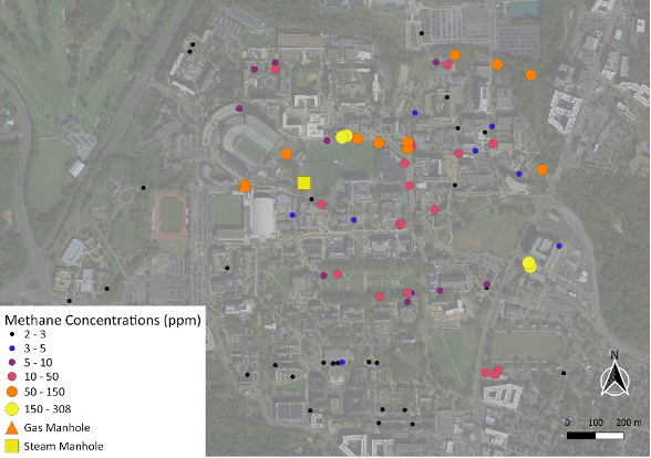
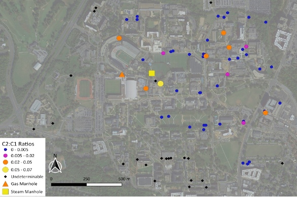
Figure 1: Preliminary methane concentration map of UMD campus sanitary sewer system. This map shows the concentration of methane (top) and the ethane-to-methane ratio (bottom) within the UMD sanitary sewer system. Areas with a higher ethane-to-methane ratio indicate potential non-microbial methane sources, such as leaks from nearby natural gas pipelines.
This work also included collection of air from manholes for isotopic measurements to evaluate sources. Microbial methane typically has depletions in methane with single and double isotope substitutions. Natural gas has intermediate level depletions in methane with single and double substitutions.
Steam and Water Waste Subproject
The team has undertaken multiple UAV flights on campus to map out steam and condensate return utility pipes. Using the heavily modified FreeFly Alta-x (Debbie), equipped with a magnetic gradiometer array, FLIR cameras, and LIDAR, the team successfully mapped buried utility infrastructures. These flights, part of an undergraduate senior project by Meyer Taffel, contributed to broader efforts under the steam and water waste subproject to identify critical leaks in infrastructure.
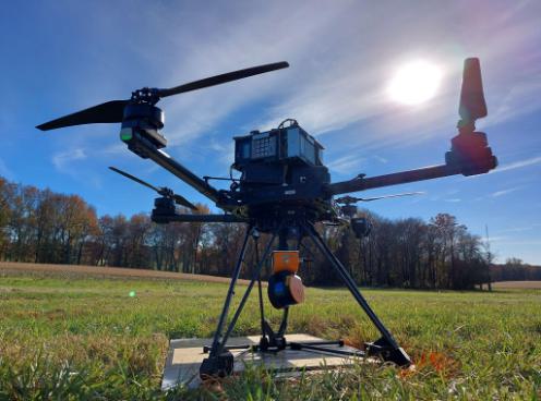
Figure 2: Current UAV system used for mapping campus utility pipes. This image shows the team’s heavily modified FreeFly Alta-X drone, nicknamed "Debbie," which is equipped with a magnetometer array, FLIR camera, and LIDAR system. This advanced setup allows precise near-earth mapping of buried steam and condensate return utility pipes on campus.
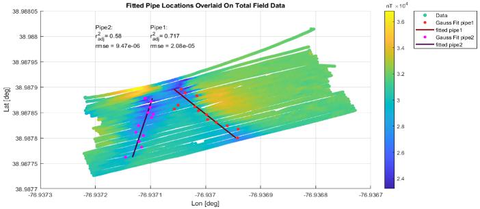
Figure 3: Mapping results of buried utility infrastructure on UMD's engineering field. This map illustrates the locations of steam and condensate utility pipes buried beneath the UMD engineering practice field, detected through UAV flights and advanced sensor systems.
Methane Subproject – Expanding Statewide Efforts
The team’s methane subproject extends beyond campus boundaries with the goal of mapping emissions across the state. Together with the Civil Air Patrol, the team will conduct airborne surveys and identified major methane emitters in landfills and agricultural areas. As part of the next phase, the team will enhance these efforts by applying machine learning techniques to the data, increasing their ability to pinpoint emission sources and propose remediation measures.
A memorandum of understanding (MOU) was approved by campus with the Maryland Wing of the Civil Air Patrol, enabling methane mapping flights across the state of Maryland. These flights, executed with aircraft outfitted with UMD's methane sensors, will identify methane hotspots in Baltimore and the broader State of Maryland.
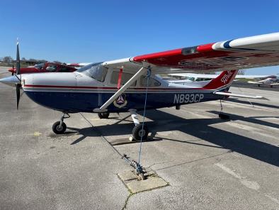
Figure 4: Civil Air Patrol aircraft will be utilized for Maryland methane emissions mapping.
This aircraft, operated by the Maryland Wing of the Civil Air Patrol, will be equipped with UMD's methane sensors and will be used for airborne surveys to detect and map methane emissions across the state of Maryland. These flights are part of a broader initiative to track greenhouse gas emissions and support environmental remediation efforts.
The methane mapping team acquired a LiCor Li-7810 system, which will be pivotal in field studies. The integration of this system has allowed for high-precision methane concentration mapping, aiding the state's efforts to evaluate large-scale methane emissions and hotspots. The system will be used for both aircraft-based measurements as well as field measurements associated with local methane hotspots such as the Brown Station landfill in Prince Georges County.

Figure 5: Methane mapping equipment used for aerial and ground studies.
Post-doctoral researcher Ed Strobach displays the LiCor Li-7810, a portable, suitcase-sized methane analyzer used in airborne and ground-based methane concentration mapping efforts across Maryland.
Campus Creek Project Accomplishments
Dr. Karen Prestegaard and undergraduate student Charlotte Macko have installed a total of nine stream gauges on Campus property, four upstream in the non-urban portion of campus creek (on the Golf Course), and five downstream in Campus Creek, Guilford Run, and effluent channels draining from campus. These gauges provide continuous monitoring of discharge. The team also takes bi-weekly samples of water chemistry. Preliminary data indicates that water sources (stormflow, groundwater, and campus effluent) can be identified via discharge timing, specific conductance, and water temperature.
Next Steps
The team’s next steps involve continuing the methane mapping campaigns across Maryland and building a more comprehensive inventory of emissions. The team will also focus on collaborating with campus Facilities Management and Washington Gas (the campus natural gas provider) to prioritize remediation efforts on steam and water waste, ensuring reduced emissions and improved environmental quality on campus.
For more information, visit: https://research.umd.edu/methane